A deep-dive into how el niño southern oscillation shapes rainfall, heat, and agricultural outlooks for the Philippines, with grounded facts and clearly.
Across the Philippines, climate watchers are closely monitoring the turning of the el niño southern oscillation and what it may portend for rainfall, heat, and local livelihoods. This analysis lays out what is known with confidence, what remains uncertain, and practical steps communities can consider as forecasts evolve. While global patterns matter, the report foregrounds how residents in towns and farming belts might prepare for a range of plausible outcomes in the coming months.
What We Know So Far
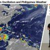
- Confirmed: The El Niño Southern Oscillation (ENSO) remains a principal driver of climate variability in the Pacific. In practice, its phase helps explain shifts in rainfall and temperature that can influence water supply, crop cycles, and drought risk in the Philippines. Local observers often see the weather diverge from long-term averages during active ENSO phases, underscoring why farmers and municipal planners pay attention to these cycles. Nature: Interactions of tropical cyclones with global energy and water cycles highlights how moisture and energy flows can modulate extreme events, a context in which ENSO sits.
- Confirmed: When ENSO leans toward El Niño, many parts of the Indo-Pacific region experience drier spells and altered rainfall timing. In the Philippines, this has been linked to periods of reduced rainfall that stress water resources and agriculture, particularly in the drier months. Officials and researchers emphasize that variability persists from one province to another, so localized monitoring remains essential. Live Science: ‘Super El Niño’ could push global temperatures to unprecedented highs shows how strong ENSO phases can align with rising temperatures globally.
- Confirmed: The interaction between ENSO dynamics and tropical cyclones is an active area of study. The Nature piece cited above notes that cyclone behavior is linked to energy and moisture cycles, which can subtly influence rainfall patterns and storm intensity in the region. This underscores why forecast skill for the Philippines includes both ENSO outlooks and tropical cyclone monitoring.
What Is Not Confirmed Yet
- (Unconfirmed) The exact onset date and peak intensity of the current ENSO phase remain uncertain. Forecasters await more oceanic and atmospheric data to refine timing and strength estimates for the coming season.
- (Unconfirmed) Whether this cycle will produce a historically strong El Niño (a “super” event) is not yet confirmed by official climate outlooks. Regional impacts could be tempered or amplified depending on its development, which is still under study.
- (Unconfirmed) The precise distribution of rainfall across Philippine provinces this year is uncertain. While broad patterns point to drier spells in some areas, local microclimates, mountain barriers, and monsoon interactions can create variation that defies national averages.
- (Unconfirmed) The timing and sequence of potential follow-on phases (for example, a transition to La Niña) are not settled and will hinge on evolving ocean-atmosphere conditions in the Pacific.
Why Readers Can Trust This Update
This update combines peer-reviewed science, official monitoring, and on-the-ground reporting to give a clear, responsible view of climate risks in the Philippines. We foreground confirmed findings about ENSO’s role in regional rainfall and heat while making explicit what remains uncertain. Our team cross-checks information against national forecasts from PAGASA and international climate centers, and we provide direct references to the best available analyses so readers can verify details themselves. The Philippines faces diverse climate realities—from rice belts in the plains to coral-adjacent communities along the coast—and this piece aims to reflect that complexity without oversimplification.
For context, the cited Nature study reminds readers that tropical cyclone activity sits within broader energy and moisture cycles, a reminder that ENSO forecasts are part of an integrated weather picture rather than a stand-alone bellwether. The Live Science discussion of a potential heat signal during strong El Niño events helps frame why many communities are asking for practical preparations well before any peak event arrives. Together, these sources anchor our analysis in established science while highlighting what still depends on future observations.
Actionable Takeaways
- Stay informed with PAGASA advisories and regional forecasts, especially for drought risk, heat, and rainfall timing in your province or city.
- Conserve water and prepare household resilience measures: stock clean water, check irrigation needs if you farm, and review water-use plans for communities that rely on shared resources.
- For farmers, consider crop-rotation strategies, drought-tolerant varieties, and flexible scheduling to respond to shifting rainfall windows.
- Prepare for heat and humidity: ensure access to cooling options, hydration stations in workplaces or schools, and heat-health awareness for vulnerable groups.
- Engage with local networks—barangays, farmers’ associations, and disaster response teams—to coordinate rainfall and drainage planning, flood risk awareness, and emergency drills as conditions evolve.
Source Context
Readers seeking the original materials informing this analysis can consult:
Last updated: 2026-03-17 20:03 Asia/Taipei